Monday June 7 1999
Start Location: Elora, Ontario
End Location: Fergus, Ontario
Total Distance: 200 kmsAll photos are video captures. I will be loading my still photos
in the next few days.
All the elements for some very strong to severe thunderstorms
were in place for Southern, Central and Eastern Ontario. The capes were running 3000, Li's
around -5, TTs around 52 and dewpoints to 23C. The only thing that was need was a
trigger. Looking at the outlooks from E.C and NSSL, the main threat today was from
strong winds and large hail. The winds were not conducive of tornadoes forming (although
they can if storms become strong enough). I was watching an upper level disturbance
crossing Lake Huron and this was the trigger I was looking for.
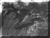
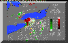
NASA Sat Image
I was watching intently to see if this wave work start
kicking up some thunderstorms as it hit ground. The first radar images I got
indicated that things were starting. At this time, a few people near Mitchell had sent me
e-mails say a large thunderstorm had blown up near the area. After thanking them, I
got the equipment in my work truck (big 4 door dually) and got ready to head out. My truck
had a broken door and was not going to be ready for today's chase.
After watching another 20 mins, I figured that these storms
were going to stay together and intensify so I left about 1:00pm. I decided to head
towards Kitchener with the scanner running and my radio tuned to AM static. There
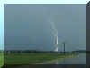
was so much lightning with the approaching storm that it was all pulses. This storm
was definitely intense and growing severe. I then headed northward towards St Clements. At
this time, the scanner was losing the weather alert station but I caught a few sentences
indicating that they had issued a severe thunderstorm warning for this cell. As I pulled
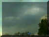
about 2 kms east of St Clements, the lightning was very evident with lots of CG's and the
rain core was monstrous. This was a classic single cell thunderstorm with a beautiful
overhanging anvil, excellent inflow and a beautiful base. There was no way I was
going into that rain mess but it was a very large cell with tops at least 45,000 in the
air.
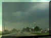
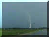
At this time, the outflow from the storm hit
and put up a dust cloud about 40 feet in the air tracking across the a big gravel parking
lot. As I was in the southwest section of the storm, I decide to let it pass and
then follow it back home. I had thought I had seen a possible wall cloud formation
to the base but, after looking at the storm structure a few more minutes, this was not so.
I had seen an nice inflow formation on the cell that dissipated and thus gave the
appearance of a weak wall cloud outline on the dark rain core. This could have also
been reported as a false funnel with it's characteristics. There was no rotation in
the cell at all. I misjudged the speed and now had to play catch up with it. I managed to
run into a few areas that had some minor wind damage but nothing to report in about.
As this storm tracked to the east I could see some additional cells blowing up to
the south of me in the distance with the towers going up hard and straight. This was
turning into a multicell cluster storm line which would be expected.
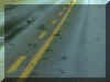
Tree Damage |
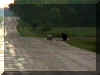
Mail Delivered By Snail? |
What to do?, I headed for home. This series
of thunderstorms was heading for Toronto and I was not going to chase in or around that
area. I received a phone call from 570 News asking if I would be available for an
interview at 6:10pm and told them I was presently chasing but would be as the storms
should be by the region by then. As I got home around 2:40 pm, I noticed that
some of our lawn furniture was toppled as the cell had passed just south of my house. I
checked the radar and noticed that the cells I saw to the south had merged as they
approached Toronto and intensified. I figure they hit the Lake Breeze boundary which
caused some additional lift to be added. They also took a bow echo style shape indicating
some strong winds would be associated with it. I quickly got a wind velocity radar and
noticed that there was a 70 know wind difference in the system. Here is a radar animation (300k) from start to finish of the storms
in Ontario from 12:30 to 4:30pm that I created for the site viewers.Must see!!
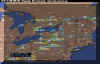
Radar Summary |
Wind Velocity |
Toppled By Wind |
As the reports of wind damage came in, I
noticed that another few cells had formed just north of Kitchener again. I think
that the cold outflow and the past thunderstorms had left a boundary in this area and
caused 2 more cells to start to build. I decided to head out to almost the same area but
decided to head towards the Elmira/Elora area so watch it track east. At this time The
Weather Network called and asked what I had saw and forwarded some of the damage reports
starting to come out of Toronto including a possible tornado. Now I was in a
quandary. Maybe this cell had changed when it merged with the second cell but I could not
make that call and E.C and The Weather Network were heading to the scene to view it so I
went for my second chase of the day.
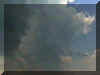
The lightning started to pick up with this cell but not to
the intensity of the last cell. This cell was still forming as I passed under it and
a weak precipitation core evident. As I got on the back side of this cell, the
second cell had died and thus I was on a single cell thunderstorm. This cell was
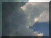
building beautifully with some strong towers going up. I tracked it into Fergus and headed
east to Belwood where I pulled over and watched it. The forming anvil collapsed on
itself and became mushy and the small towers popping up behind it were weak.
Eventually the cell collapsed on itself and died within 20 mins. I arrived
home at about 4:45pm and saw that cell had died almost immediately after I saw it go
mushy.
I stayed close to the computer and got some additional
reports for people talking about the tornado and was asked what I thought. No way to
comment until E.C issued the report on the microburst. After doing the radio interview
from 6:10 to 6:40 on 570 News, I headed out to Burlington for the night.
A great 2 chase day with some beautiful cell development.
Unfortunately other areas received some damage from the storms. I heard that many
were surprised when these storms came when they talked to the news. Guess they are
not using my site! :)
Additional Information:
Environment Canada has confirmed that a microburst (that have winds in
excess of 160 kph at times) did the damage in the Dundas and 427 area at around 3:30 pm.
Microbursts are intense downdrafts formed as the result of hydrometeor drag and
evaporative cooling during the mature stage of a thunderstorm. Some Photos are Here. and a
broadcast from CBC Newsworld and additional information is here
I have also received information from a friend of mine that
works at the airport and he said a plane was trying to land and was shot 300 feet up due
to sheer in 1/2 a second and, at that time, the airport closed and planes were diverted.
The wind gauge at 24L runway indicated a gust of 52 knots at that time with a
definite dust cloud front as the microburst started in that area and tracked towards the
Dundas region.
Issued By Environment Canada outlining Microburst
and Damage Reports.
WOCN10 CWTO 072145
GENERAL WEATHER STATEMENT
ISSED BY ENVIRONMENT CANADA. REGIONAL CENTRE TORONTO ONTARIO.
5.45 PM EDT MONDAY 7 JUNE 1999.
TORONTO WIND DAMAGE FROM A MICROBURST..
AN ENVIRONMENT CANADA OFFICIAL HAS DETERMINED THAT WIND DAMAGE TO A BUILDING IN THE DUNDAS
AND KIPLING AREA WAS FROM A MICROBURST AND NOT FROM A TORNADO. A ROOF WAS RIPPED OFF..WITH
MOST OF THE DEBRIS BLOWN FROM THE NORTHWEST TO THE SOUTHEAST..INDICATING STRAIGHT LINE
WIND DAMAGE AND NOT A TORNADO.
WOCN10 CWTO 080104
GENERAL WEATHER STATEMENT
UPDATED BY ENVIRONMENT CANADA. REGIONAL CENTRE TORONTO ONTARIO.
9.10 PM EDT MONDAY 7 JUNE 1999.
SEVERE THUNDERSTORMS CAUSE WIND DAMAGE IN PARTS OF SOUTHERN ONTARIO..
A COLD FRONT SWEEPING ACROSS SOUTHERN AND NORTHERN ONTARIO TODAY TRIGGERED A ROUND OF
SEVERE THUNDERSTORMS ACROSS THE DISTRICT AS IT PLOUGHED INTO VERY WARM MOIST AND UNSTABLE
AIR OVER THE AREA.
SEVERE THUNDERSTORM WATCHES WERE ISSUED AT 10.40 AM THIS MORNING FOR NORTHEASTERN
ONTARIO..THEN EXPANDED TO COVER ALL OF SOUTHERN ONTARIO EAST OF WINDSOR TO THE
OTTAWA-HULL-CORNWALL AREAS AT 1.01 PM. THE FIRST SEVERE THUNDERSTORM WARNINGS WERE ISSUED
AT 1.42 PM FOR
PARTS OF PERTH AND WELLINGTON COUNTIES..THEN EXPANDED EASTWARD TO THE TORONTO AREA 2.36
PM. SOME 30 MINUTES LATER..THE SEVERE THUNDERSTORMS RAMPAGED INTO THE CITY PRODUCING
STRONG WINDS AND HAIL IN A NUMBER OF LOCALITIES.
NUMEROUS SEVERE THUNDERSTORM WARNINGS WERE ALSO ISSUED FOR EASTERN ONTARIO AND PARTS OF
NORTHEASTERN ONTARIO LATE THIS AFTERNOON.
FOLLOWING IN THE TABLE BELOW ARE REPORTS RECEIVED BY ENVIRONMENT CANADA. IN ADDITION TO
THESE..THERE WERE A NUMBER OF REPORTS OF SMALL HAIL..HEAVY DOWNPOURS..INTENSE LIGHTNING
AND GUSTY WINDS WITH MANY OF THE THUNDERSTORMS ACROSS THE PROVINCE TODAY. THIS BULLETIN
WILL BE UPDATED UPON RECEPTION OF MORE REPORTS.
TIME LOCATION EVENT/COMMENTS
1:25 PM NEWTON (15 KM NW DAMAGING WINDS KITCHENER) HAIL OF UNKNOWN SIZE
2:00 PM GUELPH WIND GUSTS TO 80 KM/HR
2:55 PM BRAMPTON 1 CM DIAMETER HAIL
3:15 PM ETOBICOKE DEBRIS ON ROAD ROOF TORN OFF BUILDING
SEVERAL VEHICLES MOVED STRAIGHT LINE WIND DAMAGE FROM
THUNDERSTORM MICROBURST
3:15 PM OAKVILLE TREES AND POWER LINES DOWN
3:20 PM TORONTO (YONGE/EGLINGTON) VERY HEAVY DOWNPOUR
3:25 PM DOWNTOWN TORONTO
(BAY & FRONT) 0.5 MM DIAMETER HAIL
3:26 PM TORONTO ISLAND ARPT WIND GUST OF 41 KNOTS
3.30 PM TORONTO DOWNTOWN 6 INCH DIAMETER TREE LIMB DOWN
3:30 PM VAUGHAN (HWY. 7 & WESTON RD) POSSIBLE FUNNEL CLOUD
4:00 PM ORILLIA DIME SIZE HAIL
4:15 PM BRAMPTON TREE DAMAGE, FENCES DAMAGED
4:15 PM OSHAWA ROAD-SALT SIZED HAIL..STRONG WINDS
4:33 PM EARLTON WIND GUSTS OF 76 KM/H
4:42 PM EARLTON WIND GUSTS OF 109 KM/H
4:45 PM MUSKOKA 2.0 CM DIAMETER HAIL
5:45 PM ALLISTON PEA SIZE HAIL
All Photos and information unless otherwise noted are
copyrighted 1999 by Dave Patrick. Any use other than authorized by them is against
the law. If you wish to contact me regarding use of these photos, please e-mail me. I have left any copyrights off
the images to show the images unaltered digitally (except where stated)
|