Saturday July 31, 2025
Start Location: Fergus, Ontario
End Location: Fergus, Ontario
Total Distance: 590 kms.
Background:
Late Friday night(2 am), I checked the radar when I got home and saw a line of strong
to severe thunderstorms in Upper Michigan tracking towards southern Ontario. I plotted a
track that would have them arrive at about 9 am in the morning. I also ran the models and
saw that the threat would be with us for most of the day all over the Southern Ontario
region with LIs to –6 and Capes to 2000 with the cold front and numerous troughs
moving threw. So off to bed I went for a few hours sleep.
Radar
Animation of The Day (570K) 10 Am to 4 PM
Chase #1
I awoke at 8:15 am to thunder. Jumping up I checked the radar and saw that the storms
had picked up speed and were here 30 mins earlier than I figured. I saw that a severe
thunderstorm was occurring to my northwest and decided to head out to this one. I wondered
why my weather alert did not activate this morning as a warning had been issued. It was
not broken, the alert tone was not activated for Wellington. Regardless, My target area
was north of Belwood and away I went.
I arrived north of Belwood at around 9:15 am as the cell moved eastward. There was some
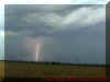
gust winds to 60 km/h, torrential rains and some really intense lightning. These storms
were going to be electric today. I shot some video of the lightning before I noticed a
cloud of smoke to my southeast.
I decided to track that way and saw a huge hay bale fire. Numerous emergency vehicles
were already there and another person watching (think it was a Canwarn spotter) said that
lightning caused it.
After shooting a few minutes of video, I head back home.
Just outside Fergus, I saw a 18 Wheeler rig in the ditch. The intense rain and the hill in
the area, combined with him going to fast, caused him to end up in the ditch from braking.
After this I headed home to check the radar and possibly get a nap in before this
afternoon. I got home and had a message from Dave Raynor. He was working at the airport
and unable to chase but, after speaking with him, he said he would forward info and status
messages that the airport got and maybe hook up after work if things were still popping by
then.
Chase #2
I arrived home and clicked on the radar. Some small cells were forming to my west near
Stratsford. After chatting with a few chasers online, I decided to watch this development
over coffee. The morning nap was out. The unstable atmosphere present dictated that any
storm cells that fired up could become severe very quickly.
Weather Forecast Images:
Satellite 1415UTC |
Satellite 1545UTC |
Dewpoint 15Z |
Lifted Index 15Z |
At 12 pm, I decide to head north of Fergus
and watch these cells develop. Lightning was intensifying as I arrived and these cells
were tracking eastward. I received a call from Laura Duchense and she asked what and where
I was. I said I was on my second chase of the day and just north of Fergus tracking
southward to these newly developed cells. She said she planned to head out soon and I told
here I would call if I saw anything with the cells I was on. At 12:25 pm, a severe
thunderstorm warning was issued. As I was on the north side of the cell I tracked to the
east and south to get ahead and south of this cell. It was really building quickly. As I
shifted to the south of this cell I noticed another one forming further south. Time to
choose. As the south one was intensifying quickly as well I decide to head further south
and intercept that one. I did not like the dynamics of the Fergus cell and wanted to set
up for a better scenario of spotting.
After heading towards Moffat, I tracked westward. As I rounded a corner, Lightning
struck a field directly in front of me (100 feet). The ground kind of exploded with dirt
and steam after the strike. What a sight but no camera on so I pulled over into a driveway
and turned on the video. As I was observing I saw lightning strike a power transformer and
caught that on video with some of the fuses damaged afterwards. Check the sparks out in
frame #5. This video is shaky and jumpy due to quick capturing and movement by me but the
images look good.
At this time I followed around the
backside of this cell and watched some impressive lightning and cloud development and
decided to head back to Fergus.
About 10 mins outside, a tornado warning was issued at
1:40 pm for a cell near Arthur so back up I went. Laura Duchesne called me to relay the
warning and was on that cell but was not seeing any development with it. As I approached
Fergus, I saw the top of the cell with the warning and it was mushy indicating it was
weakening. However, to my west, rapid development of 2 cells was underway again. It seemed
like my house was a front and every storm decide to fire up here. Asking her what she was
seeing, I began to wonder if E.C. had called the wrong cell tornadic as this one had some
good shear and development in the updraft core. I headed further north as these cells were
tracking that way and I want to get into a good position.
As I got about 10 kms north of Fergus, I noticed that the cells had turned and shifted
south again. This was an ongoing problem. Cells were firing up and initial tracking
eastward and then swinging on a southeastward track. So I was out of position and not in
the place to see anything. I decided to track east a little just north of Belwood to see
if I could get a patch of clear air to see if anything was developing to the northwest. I
noticed a RFD (Rear Flanking Downdraft ) line coming out of the cell that Laura was on but
it was weakening and no new development was seen.
As the lightning diminished on radio and there was no visible lightning strikes in my
area, I made a quick phone call to Laura indicating the area of was dying out and that the
development was heading south. I headed home at 3:00 pm to check radar and forwarded the
new information to her. There was only one area that was showing any decent development
and that was over Kitchener. Looking at radial velocity level 1 & 2 radar and echo
tops radar, I detected a slight rotation in it (at least I think it was due to
outflow/inflow values). I told here that thing was the best cell but she was in Alma and
that she would not be able to get that cell in time.
Weather Forecast Images Pertaining to Kitchener
Cell that a tornado warning was issued for in Hamilton (Same Cell):
Cell Height
|
Detailed Radar
|
Radial Velocity Level 1 |
Radial Velocity Level 2 |
Surface Obs |
|
|
|
Chase #3
Looking at the radar, there was only 2 places to go. The Kitchener cell was the most
intense of all the cells in the region or down towards Windsor with some cells tracking
eastward from Michigan. At 3:40 pm, Detroit NWS issued a tornado warning for the Detroit
Metro area. Minutes later E.C. issued a tornado warning for Windsor and then the Hamilton
cell (that tracked from Kitchener). After plotting an eastward track and noticing that
cells were firing northward of this cell along an outflow boundary I decide to make a last
play.
I headed to London and arrived there at 5 pm. Listening to Canwarn, things were not
looking good. Many cells had dissipated and the only chase-able cell was in Elgin county
heading for Lake Erie. A report over Canwarn came in from the Alymer area indicating some
small hail (below pea size) and some moderate rain and wind. The net controller decided to
round it up to pea and said that this warranted a call to E.C. Severe Weather desk. Why? I
have no clue because it is well below severe levels. However the report indicated to me
that this was not the best cell. He did mention another cell over Alviston tracking
southeast but this was not increasing of decreasing.
Cells were not forming along the outflow to the north so I went after the Alviston cell
as it would track into Elgin county. As I was way out of position, I was hoping to catch
some lightning strikes hitting the lake and got to south of Iona by 5:20 pm. As I arrived
there, the storm was over the lake but the lightning decreased significantly and I did not
get anything. This was 2 times I had been to the Windsor region this week and both were
busts. It is going to take me a big event to ever come down chasing here again.
Listening to Canwarn, the net controller stated that a few cells were firing along Lake
Huron (possibly the outflow and Lake Breeze intersection) but breaks in the clouds allowed
me to see that these were not developing all that much and actually seemed to be dying
out. I headed home arriving in Fergus at 7:30 pm tired but happy.
Today was a long chase day with my last count at 5 severe thunderstorm cells, one
tornadic but little to report beside lightning damage and some minor flooding.
Statements:
TORNADO WARNING
ISSUED BY ENVIRONMENT CANADA. REGIONAL CENTRE TORONTO ONTARIO.
1.40 PM EDT SATURDAY 31 JULY 1999.
SEVERE THUNDERSTORM WARNING UPGRADED TO TORNADO WARNING FOR..
DUFFERIN COUNTY
WELLINGTON COUNTY.
WEATHER RADAR AT 1.40 PM INDICATES THAT A SEVERE THUNDERSTORM CURRENTLY INTENSIFYING
JUST EAST OF ARTHUR IS CAPABLE OF PRODUCING A TORNADO. NO REPORTS HAVE BEEN RECEIVED BUT
CAUTION IS ADVISED. THIS IS A WARNING THAT SEVERE THUNDERSTORMS WITH TORNADOES ARE
IMMINENT OR OCCURRING IN THESE REGIONS. MONITOR WEATHER CONDITIONS. TAKE IMMEDIATE SAFETY
PRECAUTIONS. EMERGENCY MEASURES ONTARIO RECOMMENDS.. IF YOU ARE IN THE PATH OF A TORNADO
GO TO A BASEMENT OR SMALL CENTRAL ROOM AWAY FROM WINDOWS. DO NOT STAY IN A
VEHICLE.. FIND
STURDY SHELTER OR LIE FLAT IN A DITCH.
THIS WARNING IS IN EFFECT UNTIL 3.45 PM.
END/1/CHADWICK/NOGA
GENERAL WEATHER STATEMENT
UPDATED BY ENVIRONMENT CANADA. REGIONAL CENTRE TORONTO ONTARIO.
6.30 PM EDT SATURDAY 31 JULY 1999.
..ANOTHER ACTIVE THUNDERSTORM DAY IN ONTARIO..
A VERY MOIST UNSTABLE AIRMASS BLANKETED MUCH OF THE PROVINCE TODAY. THUNDERSTORM
ACTIVITY FIRED UP OVER MANY AREAS WITH SOME OF THESE THUNDERSTORMS PRODUCING HAIL..
DAMAGING WINDS AND AN UNCONFIRMED TORNADO ALONG THE SOUTH SHORE OF LAKE ST CLAIR. HERE IS
A RUN DOWN OF SOME OF THE REPORTS THAT HAVE BEEN RECEIVED UP TO 6.30 PM EDT.
EVENT TIME - EDT- : 1999/7/31: 5:30 PM
LOCALE : NOTTAWA , BARRIE-HURONIA
DESCRIPTION : TREES DOWN. BOAT CARRIED INTO NEIGHBOUR'S YARD.
EVENT TIME - EDT- : 1999/7/31: 5:15 PM
LOCALE : ST. CATHARINES , NIAGARA
DESCRIPTION : LIGHTNING.. DAMAGING WINDS AND CONSIDERABLE RAIN
EVENT TIME - EDT- : 1999/7/31: 4:03 PM
LOCALE : WINDSOR , WINDSOR-ESSEX-KENT
DESCRIPTION : FUNNEL CLOUD/POSSIBLE TORNADO
EVENT TIME - EDT- : 1999/7/31: 3:50 PM
LOCALE : 20 MILES NW OF LONDON , LONDON-MIDDLESEX-OXFORD
DESCRIPTION : WINDS APROX. 100KM/H
EVENT TIME - EDT- : 1999/7/31: 3:42 PM
LOCALE : WINDSOR AIRPORT , WINDSOR-ESSEX-KENT
EVENTDESC : WINDS GUSTING 90 KM/H. FUNNEL CLOUD REPORTED IN VICINITY OF AIRPORT BY
AMBULANCE CREW. SAW FUNNEL, ABANDONED VEHICLE, SAW DUST AND DEBRIS BUT FUNNEL DID NOT
TOUCH GROUND.
EVENT TIME - EDT- : 1999/7/31: 3:12 PM
LOCALE : 3 KM SE OF STRATFORD , HURON-PERTH
DESCRIPTION : G100 KM/H. INTENSE LIGHTNING.
EVENT TIME - EDT- : 1999/7/31: 3:00 PM
LOCALE : S OF PETROLIA , WINDSOR-ESSEX-KENT
DESCRIPTION : ROOF BLOWN OFF HOUSE AND BARN SOUTH OF PETROLIA AT ABOUT 2:50 PM.
EVENT TIME - EDT- : 1999/7/31: 2:46 PM
LOCALE : LONDON , LONDON-MIDDLESEX-OXFORD
DESCRIPTION : GUST 95 KM/H
EVENT TIME - EDT- : 1999/7/31: 2:20 PM
LOCALE : PETROLIA , SARNIA-LAMBTON
DESCRIPTION : WIND DAMAGE AND TREES DOWN IN PETROLIA. MANY AREAS WITHOUT POWER. STRUCTURE
FIRES DUE TO LIGHTNING STRIKES.
EVENT TIME - EDT- : 1999/7/31: 8:52 AM
LOCALE : SOUTH END OF BARRIE , BARRIE-HURONIA
DESCRIPTION : FUNNEL CLOUD. WINDS 110 KM/H.
EVENT TIME - EDT- : 1999/7/31: 8:35 AM
LOCALE : MEAFORD , GREY-BRUCE
DESCRIPTION : MOTHBALL SIZED HAIL
EVENT TIME - EDT- : 1999/7/31: 8:25 AM
LOCALE : NEAR BERKELEY , GREY-BRUCE
DESCRIPTION : FUNNEL CLOUD. POSSIBLE BRIEF TOUCHDOWN.
EVENT TIME - EDT- : 1999/7/31: 8:25 AM
LOCALE : MARKDALE , GREY-BRUCE
DESCRIPTION : GOLF BALL SIZED HAIL
EVENT TIME - EDT- : 1999/7/31: 8:10 AM
LOCALE : ROCKFORD , GREY-BRUCE
DESCRIPTION : MOTHBALL SIZED HAIL
EVENT TIME - EDT- : 1999/7/31: 6:00 AM
LOCALE : GREAT DUCK ISLAND , MANITOULIN
DESCRIPTION : GUST 110 KM/H
THUNDERSTORM ACTIVITY CONTINUES OVER MANY PORTIONS OF THE PROVINCE. WEATHER WARNINGS
AND WATCHES CONTINUE TO BE IN EFFECT FOR MANY AREAS AS WELL. THIS THUNDERSTORM ACTIVITY IS
EXPECTED TO DIMINISH OVERNIGHT AS A COOLER.. DRIER AND MORE STABLE AIR MASS ENTERS THE
PROVINCE. STAY TUNED FOR FURTHER WEATHER UPDATES.
END/CHADWICK
All Photos and information unless otherwise noted are
copyrighted 1999 by Dave Patrick. Any use other than authorized by them is against
the law. If you wish to contact me regarding use of these photos, please e-mail me. I have left any copyrights off
the images to show the images unaltered digitally (except where stated)
|
