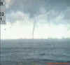
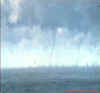
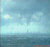
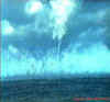
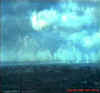
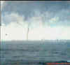
Funnel Clouds
over Lake Ontario In December 30,2024
I received these photos from Jack Kertzie, a fellow chaser, from NY
State who chases all over the place (and seems to be in the right place at the right
time). I decided to keep his e-mail as a chase account and posted his pictures
below. Although they are a bit fuzzy, they are the only ones I have seen regarding
this event and still spectacular. I also included some metars issued that were posted and
explained by Kerry-Ann Lecky (thanks Kerry-Ann), a meteorologist from The Weather Network.
Chase Account:
I was actually on business in St. Catharine's and on my way home
around 9:00 AM to Wilson. I am always looking at the clouds even in the winter over the
lake because I had already been informed that these "Steam Devils" could happen
over water during an Arctic blast of cold air. I know the water temperature was around 39
F and the ground surface air was about 9 F and the north lake wind must have been near
gale force. As I crossed the Welland canal on the high QEW bridge I was amazed to see not
one but many funnel clouds and some appeared to be full blown water spouts from the cloud
base to the water surface! I had no camera so I raced home to get my equipment and zipped
up to the lake. I too am very busy and had little sleep. In my haste I failed to take any
still photos which is a big no no. I used my video capture (old board) to freeze frame the
photos I sent you which explains the poor quality.
Anyway, It was quite a show, you could watch all kinds of funnel
development. There was no waiting. They would form and dissipate in families.
Some were large and vertical, some were twisted and roped. some stood still
and some raced along at about 30 mph. Some grew up from the water to meet the
funnel coming down from the cloud base. Many had nice smooth spinning white
funnels and most seemed to be in the center of the lake but some were near the
shore. It would seem that "twisters" are never out of season!
Photos:
St. Catharine's Metars:
METAR CYSN 301500Z 32010KT 15SM
-SHSN FC SCT015 M12/M15 A2997 RMK
SC3 FUNNEL CLOUD FC OVR LK VSBY W-S 4 SLP153
Metar Sample Decoder (provided by Kerry-Ann Lecky)
| METAR |
Aviation Routine Weather Report |
| CYSN |
station I.D. In this e.g.. it is St.
Catherines. |
| 301500Z |
30th day of the month at 15 UTC |
| 32010KT |
wind direction is 320degrees
(Northwest) ,a speed of 10 knots |
| 15SM |
visibility is 15 Statute Miles |
| SHSN |
light snow showers |
| FC |
Funnel Cloud |
| SCT015 |
Scattered layer at 1500ft |
| M12/M15 |
temp -12C and dewpoint -15 |
| A2997 |
Altimeter setting (for aviation) 29.97 Inches of Hg |
| RMK |
Remark |
| SC3 |
Stratus Cumulus 3/8 sky coverage |
| FUNNEL CLOUD FC OVR LK |
Funnel Cloud Over Lake |
| VSBY W-S 4 |
Visibility West-South 4miles?? |
| SLP153 |
Sea Level Pressure 1015.3 mb |
All Photos are copyrighted by Jack Kertzie and are used on this site
with his permission. Any use other than authorized by them is against the law.
If you wish to contact him regarding use of these photos, please e-mail me and I will forward it. |